The Phoenix Trail: Forward to Wycombe Railway - Thame Maps - Thame Categories
Go to Facts – Sites - Back to Thame Home Page – to Bob Denton Home Page
Quick Links:
We moved to Thame late in 2019. As we settled in, Covid hit and locked down the nation, including of course Thame. We only met our new neighbours through clapping for the NHS every Thursday night.
So, it was some months before we found the Phoenix Trail.

Source: www.saddlesafari.co.uk
It passed just a few minutes away from us. It runs from Thame to Princes Risborough and stretches for seven-and-a-half miles of fairly level track.
It follows a disused railway track.
Wycombe Railway Company:
The Wycombe Railway Company was founded in 1846. It was created to extend the GWR (aka ‘God’s Wonderful Railway’) from Maidenhead to High Wycombe. This was opened in August 1854. It was built using Brunel’s broad(-er) gauge of seven feet. In the 1860s the line expanded via Princes Risborough to Thame. The railway station was opened in 1862. It was constructed for c£2,200, the equivalent of £300,000 today. It added a branch line to Aylesbury, and extended the line to Kennington Junction, which was on the GWR line between Didcot and Oxford.  Thame Station was opened in 1862 as the terminus of an extension from High Wycombe via Princes Risborough The cost of construction of the station building was just £2,201 1s 5d and additional general works were a further £2,137 8s 8d. The station was built with a train-shed over its platforms.  In 1864 the line was extended from Thame to Oxford. Thame originally had a single platform with an engine shed on the south side on the location where later cattle pens were built. Between 1864 and 1893 the engine shed was demolished and a second platform was built, the trainshed roof was extended on one side to provide cover for the new platform. The station was provided with a 28-lever signal box. At the end of the 19th century, a new line between High Wycombe and Northolt Junction gave GWR a route from Wycombe to Paddington which decimated the Wycombe Railway. Ernest Marples was Postmaster General and then Minister of Transport for the governments of Harold Macmillan and of Alec Douglas-Home. As PMG (1957-1959) Marples established Postcodes, Premium Bonds and STD dialling. As Minister of Transport (1959-1964) he introduced yellow lines, parking meters, traffic wardens, panda crossings and the MoT test. So not without impact! 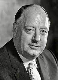 Dr Richard Beeching (source: Wikimedia Commons) On his founding of the British Railways Board he appointed an ex-ICI director, Dr Richard Beeching, to be its chairman. It was at that time losing £300,000 per day (1961). Beeching with his 1963 report, ‘The Reshaping of British Railways’, led to the closure of 2,363 stations from the then total of 7,000, eliminated 5,000 route-miles and shed almost 70,000 railway jobs across three years. Thame station closed in 1963. Beeching effectively cut the passenger rail links to many villages and market towns – such as Thame! The Thame section was closed in 1963 to passengers but was still in use for transporting fuels (gas oil, kerosene, and motor spirit) to and from the Thame Oil Depot and Princes Risborough until 1991. All of the track was removed in 1998. |
The Phoenix Trail was cleared and is now run by Sustrans. This is a charity that runs the National Cycle Network, and has created over 12,000 miles of cycle tracks around the UK, 5,000 of them being traffic-free.
Sustrans established the Phoenix Trail as part of National Cycle route 57 – it runs from Farmington in Gloucestershire to Welwyn Garden City in Hertfordshire. It is 108 kms, or 67 miles, long.

Where we conveniently join the trail, is Howland Road, perhaps one-third of the way along the trail, one-third taking us through Thame, and two-thirds running to Towersey and Risborough. Why Howland?
The Phoenix Trail: Jack Howland
| Howland Road is an innocuous road that runs from Kingsey Road to Chinnor Road roundabout, forming part of the Thame bypass. It is just 832 metres (910 yards) long, just a tad over half-a-mile in length. But it commemorates Alfred Jack Howland, born in 1915. Jack lived at 42 Wellington Street, Thame. His original roots were quite poor, not helped by his father dying on the Somme in 1916. Jack became resourceful, hunting rabbits and game on nearby estates. He also caught crayfish from the Cuttle Brook. In 1933 he joined the Oxfordshire and Bucks Light Infantry. 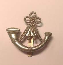 Cap badge (Source Wikimedia Commons) The Ox & Bucks had an illustrious history from both the Second Boar War and the Great War. By 1939 Jack had become one of its youngest sergeants. In 1940 Jack was part of the rearguard for the British Expeditionary Force at Dunkirk. He was captured in Arras and was a prisoner for more than four years, working in south Poland in the coalmines, quarries and fields. He successfully escaped at the third attempt. He and another sergeant hiked through the Carpathians, the Tatra Mountains, home to bears, chamois, lynx and marmot. They reached the then Czechoslovakia. They were spotted by Czech partisans who assumed they were Gestapo spies. Interrogated, they were assisted by Jack’s tattoo of his wife’s name, Eileen. Once established as escapees they joined the Belgian Strike Group. The group carried out over 600 guerilla attacks on barracks, police stations and marshalling yards. 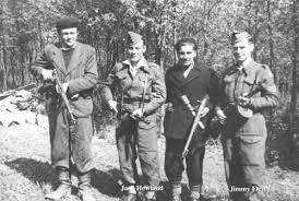 (Source: ThameHistory.net) They finally linked up with Red Army Units. Jack stayed in the army after the war, rising to the rank of major. His thirty-six-year military career was concluded in 1969. He died in 1996, aged over 80. |
Back to the Trail.
Turning right from Howland Road, this is a level tarmacked section that runs straight towards a bridge. Beside the bridge is a set of steps to give access to Chinnor Road.

(Source: www.specialfruit.com)
On the right as you set off there are bramble bushes (rubus vulgaris) bearing blackberries. Their cluster of drupelets provide a snack for the journey from July to October. An old saying has it that ‘blackberries are red when they’re green’, so make sure they are black.
This stretch has soil embankments with trees to the right. These keep the path largely in shade. There are several locations where puddles are formed, and just before the bridge the soil does create muddy areas.
To the left at the top of the embankment are the gardens for properties on Pearce Way and Lacey Drive. Several routes from those roads are regularly used (unofficially) by the residents down to the trail.

This stretch does seem to cultivate massive amounts of stinging nettle (urtica dioica). They grow tall and hang out over the path, particularly at the bridge steps; their trichomes hang there like a flurry of hypodermics primed to inject histamine and other substances into the incautious. It was Aesop (620-540 BCE) who first used the term, ‘to grasp the nettle’.
Sadly, there do not appear to be many broad-leaf docks (rumex obtusifolius) along the trail, the common remedy for nettle stings, though often dismissed as having only a placebo effect.

The trail passes under the Chinnor Road where budding Banksys are refining their art:
The remains of the platforms of Thame Station can clearly be identified:

Along the trail, Angus Ross and six furniture students from the local Rycotewood College located a series of 30 artworks, primarily using green oak. These were inspired by the old railway environment and the local landscape of the Chilterns:

The Phoenix Trail is a wonderful local resource. It is a tranquil, traffic-free route to encourage walkers, dog-walkers, cyclists and the occasional horse rider. It provides a flat and surfaced track suitable for wheelchairs and pushchairs. Seating is provided every 500 metres. Small wonder it is used routinely by many.
The Phoenix Trail: Forward to Wycombe Railway - Thame Maps - Thame Categories
Go to Facts - Sites - Back to Thame Home Page – to Bob Denton Home Page


